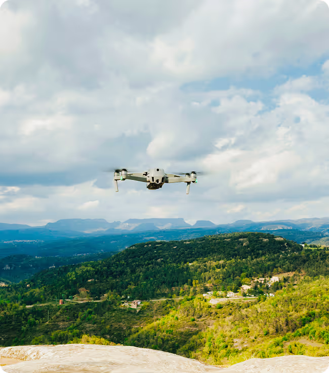
Turning Aerial Data Into Decisive Action.
100+
Deer recoveries completed
30K
Acres mapped
10K+
Acres flow for agriculture clients


industries we serve
agriculture

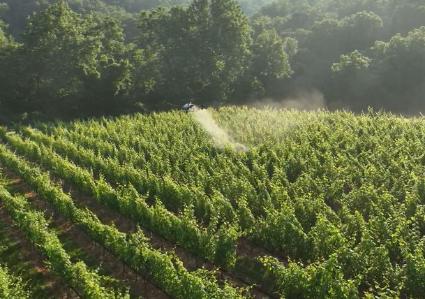
From drone-powered crop spraying to large-scale property mapping, our advanced UAV technology enhances agricultural efficiency, reduces waste, and maximizes yields with data-driven insights.
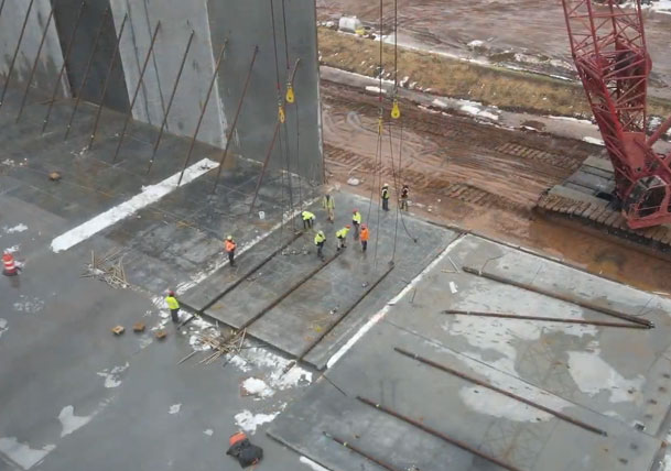
construction
Streamline your construction projects with high-accuracy mapping, LIDAR scanning, and aerial progress monitoring. Our drone solutions provide real-time data for better planning, efficiency, and cost control.
Outdoor
Whether you need property mapping, herd analysis, or terrain visualization, our drone technology helps you manage land with precision, offering data-driven insights for outdoor industries.
Media
Elevate your brand or event coverage with high-quality aerial photography and videography. Whether it’s for marketing, real estate, or documentary filmmaking, our drones deliver cinematic visuals with unparalleled precision.
agriculture Spraying
From drone-powered crop spraying to large-scale property mapping, our advanced UAV technology enhances agricultural efficiency, reduces waste, and maximizes yields with data-driven insights.
construction Mapping
Streamline your construction projects with high-accuracy mapping, LiDAR scanning, and aerial progress monitoring. Our drone solutions provide real-time data for better planning, efficiency, and cost control.
Deer Herding and Analysis
Whether you need property mapping, herd analysis, or terrain visualization, our drone technology helps you manage land with precision, offering data-driven insights for outdoor industries.

Drone Photos and videos
Elevate your brand or event coverage with high-quality aerial photography and videography. Whether it’s for marketing, real estate, or documentary filmmaking, our drones deliver cinematic visuals with unparalleled precision.
How it works
Consultation & Planning
We assess your farm’s needs and determine the best drone solutions for spraying, mapping, and monitoring.
Aerial Data Collection
Drones capture high-resolution imagery and data, from crop health analysis to precision spraying and seeding.
Analysis & Insights
We process the data into actionable insights, helping you optimize yields, reduce waste, and improve efficiency.
Execution & Monitoring
Our team provides ongoing support, ensuring your crops receive the right treatment at the right time.
Project Assessment
We discuss your site needs and select the best drone solutions for mapping, progress tracking, or volumetric analysis.
Aerial Survey & Data Capture
Drones conduct high-accuracy scans, collecting topographical, structural, and environmental data.
Data Processing & Reports
We convert drone data into detailed maps, 3D models, and analytics for informed decision-making.
Implementation & Updates
You receive easy-to-use reports and ongoing support, keeping your project on track and optimized.
Site Evaluation
We identify the specific needs for land mapping, herd analysis, or property surveying.
Drone Deployment
Drones capture thermal and high-resolution images to track wildlife, assess land, or analyze habitats.
Data Interpretation
We translate aerial data into easy-to-understand reports for conservation, management, or property planning.
Action & Follow-Up
We provide ongoing support, ensuring you have the insights needed for sustainable land use and monitoring.
Creative Planning
We collaborate to understand your vision, goals, and preferred angles for your aerial shoot.
Aerial Capture
Using high-quality drones, we film or photograph your subject from the best vantage points.
Post-Production
Our team enhances footage with editing, color correction, and stabilization for professional results.
Delivery & Distribution
Finalized content is delivered in your preferred format, ready for marketing, production, or publishing.
See How We Helped These Companies Succeed
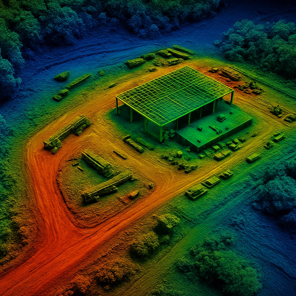
LiDAR Archaelogical Study
Lorem ipsum dolor sit amet, consectetur adipiscing elit. Suspendisse varius enim in eros elementum tristique. Duis cursus, mi quis viverra ornare, eros dolor interdum nulla, ut commodo diam libero vitae erat.
220K
Deer recoveries completed
175
Acres mapped
90%
Of acres flow for agriculture clients
Featured Case Study title will Go over Here
Lorem ipsum dolor sit amet, consectetur adipiscing elit. Suspendisse varius enim in eros elementum tristique. Duis cursus, mi quis viverra ornare, eros dolor interdum nulla, ut commodo diam libero vitae erat.
100K
Deer recoveries completed
50K
Acres mapped
10K
Of acres flow for agriculture clients
The Best Drone Solution in virginia. From Construction Mapping to Herd Analysis and Deer Recovery.
SkyHound delivers cutting-edge drone data solutions tailored to construction mapping, agriculture spraying, LIDAR scanning, drone photos, and drone videos. With advanced technology, precision-driven results, and a commitment to efficiency, we help businesses streamline operations, reduce costs, and gain critical insights from above.
Unmatched Drone Expertise in Restricted Airspace
Operating in DC, Maryland, and Virginia, we specialize in navigating FAA regulations and restricted airspace, ensuring compliant and seamless drone operations.
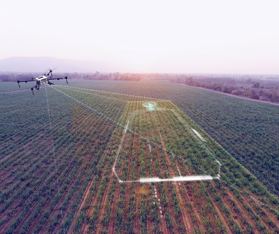
Precision Agriculture Crop Spraying & Land Analysis
SkyHound's drone-based spraying and herd analysis help farmers and landowners optimize yields, reduce chemical waste, and improve herd management with cutting-edge aerial insights.
Deer Recovery Solutions with Thermal Imaging
Our thermal drone technology assists in wildlife tracking, deer recovery, and search operations, ensuring rapid, accurate results even in challenging terrain.
Advanced LiDAR & 3D Mapping Capabilities For Complex Projects
Our LIDAR and orthomosaic mapping deliver highly accurate topographical data for construction planning, infrastructure planning, and environmental assessments.
Reliable Data for Construction And Land Mapping
From construction site progression tracking to stockpile scans, our drone solutions provide reliable, data-driven decision-making for projects of all sizes.
Drone Photos and Drone Videos For Any Industry
With years of experience in cinematic drone capture, we provide high-impact aerial footage for marketing, real estate, and outdoor adventure media.
Take Your Business to New Heights with SkyHound
Unlock the power of precision drone data to optimize your operations, cut costs, and gain a competitive edge. Schedule a consultation today and see how SkyHound can elevate your business.
hear from our clients
I shot a buck with a crossbow and didn’t have luck finding it. I called Tyler and he was out within hours!!! We searched 10X what I could do on foot and with no disturbance to other deer. We were unfortunately not able to recover the deer but it was nice to know I did everything I could to recover it and that it may survive. 1000% recommend this service.
- Eric Rutt
Had a great experience with Sky hound with their deer recovery service. They had a very rapid response and was able to make it to me right away. They have top of the line equipment and the customer service was unmatched.
- Andrew Berry
SkyHound, my next-door neighbor, so I know Tyler and trust him, did a fantastic job of thermal-assessment of my 1899 colonial, that will help me improve my house's thermal integrity. I highly recommend SkyHound!
- Jeffrey Phillips
Tyler has great drone experience and is a wonderful guy as well. He will do quality work for you
- Spencer Burns
I’ve been hunting for 50 years and have regretfully not found deer that I hit with my bow. This year I used SkyHound the day after shooting a deer an was unable to find it. The SkyHound guys found it in 20 minutes. I’m a SkyHound believer!!
- Dale D'Alessio
Incredible images and customer service! I would highly recommend.
- Kelly Clifton
Precision Mapping for Smarter Decision-Making
.avif)
lidar mapping
SkyHound’s LIDAR technology delivers ultra-precise, high-density 3D scans, penetrating dense vegetation and complex landscapes to provide the most accurate topographical data available. Ideal for large-scale land development, infrastructure planning, and environmental monitoring.
orthomosaic mapping
Our high-resolution orthomosaic maps stitch together hundreds of aerial images to create a seamless, true-to-scale representation of your site. Perfect for tracking progress, measuring assets, and enhancing land analysis with pinpoint accuracy.
Stockpile Scans
Accurately calculate stockpile volumes, track material movement, and improve resource allocation with our volumetric scanning technology. Get real-time data that helps you optimize efficiency and reduce waste.

5 min read
Understanding Aerial Maps: DEMs, Orthomosaics, and Point Clouds Explained
Drone technology has revolutionized how we capture and visualize land. But if you’ve ever received a deliverable labeled “DEMs,” “orthomosaics,” or “point clouds,” you may have found yourself wondering: what exactly do these terms mean—and why do they matter for your project?
5 min read
What Is LiDAR Mapping and Why Does It Matter for Your Project?
When it comes to land surveying and site planning, precision is everything. Whether you're developing land, planning infrastructure, or analyzing large properties, traditional surveying methods can be slow, expensive, and prone to errors. That’s where LiDAR mapping comes in — a cutting-edge solution that delivers fast, accurate data from above.
5 min read
Precision Ag: Using Drone Maps to Improve Crop Yields and Efficiency
In today’s world of farming, doing more with less isn’t just a goal—it’s a necessity. From rising input costs to unpredictable weather, modern agriculture demands smarter strategies. That’s where precision ag comes in—and drones are playing a key role in making it work.
Get Your Own Drone – Elevate Your Capabilities
Take your operations to the next level with the latest in drone technology. Whether you're looking to capture high-quality aerial data, enhance your workflow, or explore new opportunities, we’ve got the perfect drone for you.
Frequently Asked Questions
Got questions? We’ve got answers. Here are the most common inquiries about our drone services and how we can help your business leverage cutting-edge aerial technology.
01.
What industries do you serve?

01.
We specialize in providing drone solutions for construction, agriculture, hunting, and media, offering precision data collection tailored to each sector’s needs.
02.
How accurate is your drone mapping technology?
02.
Our LIDAR, orthomosaic mapping, and volumetric scans deliver highly precise data, with accuracy down to a few centimeters, ensuring reliable insights for your projects.
03.
How do I get started with your services?
03.
Simply contact us for a consultation! We’ll assess your needs, recommend the right solution, and guide you through the process from data collection to final delivery.
04.
Are your drone pilots certified?
04.
Yes, all of our pilots hold Part 107 certifications and have extensive experience operating in controlled airspace, ensuring safe and compliant operations.
05.
How much do your drone services cost?
05.
Pricing varies depending on the project’s scope and complexity. Contact us for a custom quote tailored to your needs.